Transitland Station Editor is a full-featured and commercially supported package for creating GTFS-Pathways data. Transit agencies and their vendors use Transitland Station Editor to integrate detailed station accessibility data into their existing GTFS feeds.

Benefits of GTFS-Pathways
By adding Pathways data to their GTFS feed, a transit agency can:
- enable riders in wheelchairs to plan trips to stations that accomodate their needs
- enrich wayfinding directions with station entrance/egress locations, names, or codes
- help routing engines to more precisely calculate the time riders need to transfer through a large stations
GTFS-Pathways data is consumed and displayed by Google Maps, the Transit app, Interline’s analysis tools, and more.
For a case study of GTFS-Pathways in action, see this blog post about Interline’s work mapping 35 regional transit hubs in the San Francisco Bay Area for the Metropolitan Transporation Commission.
Features
Transitland Station Editor is offered as a fully managed “software as a service” (SaaS). Subscriptions include:

- desktop and tablet access via web browser
- user accounts for an unlimited number of staff members
- aerial imagery basemap (with a commercial license that allows users to trace station outlines)
- built-in validation logic to ensure that data complies with the GTFS-Pathways specification
- built-in testing to ensure GTFS-Pathways data for a station is topologically connected, without broken, disconnected “islands”
- documentation, including Interline’s “GTFS-Pathways style guide” based on our team’s experience creating GTFS-Pathways data for dozens of real-world stations
- an onboarding training call by video and ongoing professional support by email
Questions & Answers
What is GTFS-Pathways?
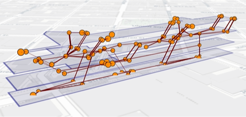
GTFS-Pathways is an extension to the GTFS transit schedule data specification to describe the layout and accessibility of transit stations. Pathways are topological representations that use stop “nodes” and pathway “edges” to articulate the network structure of a station. Stations can have multiple levels, with stair, escalator, and elevator pathways connecting the levels. Pathways can be marked as accessible to riders in wheelchairs, with strollers, with bicycles, and other specific mobility requirements. Entrances, exits, and boarding platforms can be labeled with names and codes, which riders can use to match directions in trip-plans to in-station signage.
What type of station complex can be mapped using Transitland Station Editor?
Transitland Station Editor can be used to map a wide variety of stations: multi-level station complexes, underground subway stations, transit centers surrounded by bus bays.
If we create GTFS-Pathways using Transitland Station Editor, do we also need to use the entire Transitland platform?
No. Transitland Station Editor provides multiple means for publishing GTFS-Pathways data. Export the data to include in your agency’s existing GTFS systems. Or optionally host your GTFS feed directly from the Transitland platform.
Learn More
To learn more about Station Editor capabilities and pricing, please contact us. Let us know about the type and number of transit stations for which you would like to create and/or maintain GTFS-Pathways data.

